Tuesday, August 5, 2014

Truro Cathedral

Truro Cathedral is the location of the annual runout concert for the St. Endellion Summer Festival.
It is a beautiful cathedral from 1910 and was the site of the first Nine Lessons and Carols in the UK (around Christmas time). Last night we performed Bach's B minor Mass in this wonderful space. It was played to commemorate the outbreak (to the day) of WW One. 

Here are some photos of the inside and outside of the cathedral.

Front of cathedral.
Pre-concert.
Side of cathedral.
Back rose window.

Detail on front column.
Concert poster outside.
Back of cathedral with a singing bird.
View from side street. Note how the cathedral towers over the other buildings in downtown Truro.

It is a beautiful space to play (and worship).


Epphaven Cove and Beach, Cornwall


I was introduced to another beach nearby. It is much smaller and more intimate than the beach at Polzeath. I prefer this one. It is called Epphaven. To get there from St. Endellion Church you walk down the road by the rectory. Keep going straight past the Longcross Hotel and you will get to Port Quin harbor. Go up the road on the far side of the harbor, as you would go to Doyden Castle. Head towards Doyden via the public footpath. Go past Doyden where you will see a sign pointing to Epphaven. It is a bit of a climb up then down. You will see the beach below.

The way down to the beach is a bit of a scramble down on rocks. Here is a view from the bottom looking up.


Once you get down to the beach the view is lovely.


Out a ways in the water you will see a mound sticking out. That is called the "Rumps". To the left of it is a headland sticking out in the water, called "Pentire Point". See photo below.


Beyond Epphaven there is another cove and beach called "Lundy". I did not make it there, but you can see it from this photo. It is the next cove over from Epphaven, around the corner. There is a nice beach there as well.


Here is a nice view of the cliffs and Doyden Castle on the walk back towards Port Quin.


It was a wonderful hike full of cliffs and coves. I highly recommend it.


Port Isaac, Cornwall UK

This charming coastal village of Port Isaac is one of my favorite places on earth. I fell in love with its beauty through the television show Doc Martin. 

I walked down there the other day from St. Endellion Church. The route I took was all paved roads, past the rectory and straight until you turn right on a paved road not suitable for heavy vehicles (so the road sign says). The walk took me about 45 minutes. It was mostly downhill on the way there and uphill on the way back. When you get to Church Hill Street the road is quite steep.

Here is a view from Church Hill Street as you approach Port Isaac.


This road drops you close to the harbor. Often you will see fishing cages lying about. 

The harbor is lovely with boats bobbing in the water.


Here are a few scenes from the Doc Martin TV set that you will recognize.


The pub above was called the "Crab and Lobster" in the show.

My favorite ice cream and ice cream shop are up the hill across from the Old School House. I especially love the Roskilly's salted caramel flavor. Sorry there is no photo of the actual ice cream itself. It's all in my tummy now!


Last summer I saw some Doc Martin filming in this exact spot, but in watching all of season 6 I could not find this scene. It must have got cut.


The way back to St. Endellion Church is a steep one via Church Hill Street. 


Once you get to the top of the street it is not as steep of an uphill climb back to the church.

In this photo from Port Isaac you can see Church Hill Street in the distance going steeply straight uphill
(the road going up the hill).


Friday, August 1, 2014

Cornwall Coastal Path from Port Gaverne towards Trebarwith Strand

I started out my hike at Port Gaverne. Port Gaverne harbor is rather small. Here it is.


There are a few buildings in the harbor area. An obvious one is the Port Gaverne hotel. Right next to the hotel you will see a wooden sign with an arrow indicating the coastal path is that a way (direction Trebarwith Strand). It is a rather steep walk uphill on gravel. You will end up at a road. Cross the road and turn right. Walk a few paces and you will see the next wooden sign for the coastal path.
The path is now more of a dirt one with stiles to crawl over.

Once you start ascending the cliffs you have a nice view of Port Gaverne behind you and the road leading back to Port Isaac.

In front of you is a view of long cliffs jutting into the water. That is the Tintagel and Boscastle area, where King Arthur lore abounds.


The path towards Trebarwith Strand is rather steep with lots of ups and downs. Often the path is very close to the edge of a cliff. Sometimes there are fences and hedges to make you feel a bit more safe.
Sometimes there is not. Be careful! Not for the faint of heart! Here is a view with a fence protecting you.


Now imagine that the fence is not there. A little daunting!

Here you can see the steepness of the path as it goes uphill.


I stopped at a nice overlook with a bed of purple heather.

This was my stopping point of the day. I did not have time to go further. It is around 6 miles from Port Gaverne to Trebarwith Strand. Some people we met along the way had walked from Tintagel. I think it took them at least 3 hours to get to Port Gaverne.

On the return trip to Port Gaverne we saw some Cornish cows grazing on the cliff.


The following photo sums up the gorgeous view of cliffs towards Port Gaverne.


All I can say is wow, what a view!

Well worth the effort to walk this portion of the coastal path from Port Gaverne towards Trebarwith Strand.


Monday, July 28, 2014

Cornwall Coastal path from Port Quin to Port Isaac

I started out my walk in Port Quin, a former fishing village that now has mostly holiday cottages. Many of those cottages were formerly fishing cellars used to cure sardines and herring. Trade was done from the harbor with goods such as fish,coal, manure, lead and granite going out and coming in. There were mines nearby. When the fishing dried up and the mines closed, many villagers left Port Quin. The village became deserted. Now it is a small resort town. Here is the harbor of Port Quin from a hill opposite the harbor.


On a hill of its own off to the side of Port Quin harbor is Doyden Castle. This castle was the filming location for the Doc Martin TV episode when baby James was kidnapped and held hostage by Mrs. Tischel, the pharmacist. It is now owned by the National Trust and rented out at a ridiculously high price. It was built in 1827 for a wealthy merchant from Wadebridge. It was his party house.


Below is a picture of both the harbor of Port Quin and Doyden Castle, so you get the perspective of where they both are.


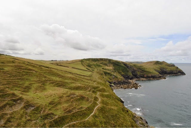
The path between Port Quin and Port Isaac takes you across flat places with hilly climbs and descents in between. The terrain of rolling hills, walled in pastures and ocean cliffs leaves you in awe of nature.
Here is a good example on the path to Port Isaac, outside of the Port Quin harbor area.


As you continue on towards Port Isaac, you reach the headland called Varley Head. In 1903 five fishermen were fishing a mile off the headland when they captured a large shoal of fish in their nets. Their boat began to sink under the weight of the fish, so they had to abandon ship. The one fisherman who could not swim was tied to an oar. The others attempted to swim to shore. The only fisherman to survive was the one hanging on to the oar. He was rescued. The others perished at sea.
Here is Varley Head.


As you continue walking towards Port Isaac you encounter steep stairs. Fortunately these ones you descend. Looking behind you is one impressive path you just descended. Here it is.


A really nice view overlooking Port Isaac is from a solitary bench on the side of a hill. I ate my lunch there. Here was my view. I could have sat there all day!


The view of Port Isaac's harbor was splendid that day. The tide was pretty low, which is typical in early afternoon. The water was slowly creeping in towards shore.


Fishing cages abound in Port Isaac harbor. They were just lying about.


You can't leave out familiar buildings from the TV show Doc Martin when you talk about Port Isaac (aka Port Wenn in the show). How about a view of Bert's restaurant and Doc's surgery from the harbor?


The walk from Port Quin to Port Isaac is a challenging 2.5 miles. It is well worth the effort. The views are spectacular. The sound and smell of the ocean and the feel of the ocean mist is refreshing.


Wednesday, November 13, 2013

Underground Museum in Cracow- below Cloth Hall (Sukiennice)

The Underground Museum in Cracow (below the Cloth Hall or Sukiennice) was opened in 2010 after a long archaeological dig started in 2005.  The permanent exhibit down below is called "In the Footsteps of Cracow's European Identity". It covers the span of the city's history from the first settlers in the region until the death of Pope John Paul II in 2005, a few months before the dig began. 

The museum is open daily. On Tuesdays the admission is free, however the hours are shorter on that day. Every first Tuesday of the month the museum is closed. Admission is rather steep for Polish standards - 19 zloty, but is a pretty good price in American dollars. It is highly recommended that you reserve your tickets in advance, as they are often sold out. You reserve a particular entrance time. Reservations can be made online or in the ticket office in the Cloth Hall (on the opposite side of the building from the museum entrance). Even on the free Tuesdays a reserved entrance time is required. 

The information on Medieval trade in Poland is quite comprehensive. The exhibits show various goods that were traded, such as copper, lead and salt. Copper was often in the form of a disc; salt in the form of a cylinder and lead in the form of a slice of bread. Copper would often come from Hungary and go to Poland, whereas salt and lead would come from Poland and go down to Hungary.Salt mining centers in Poland were in Bochnia and Wieliczka. Much of the profit from the salt mining would go to the King of Poland (ie. Kazimierz the Great used the money to endow Jagiellonian University in Cracow.)
Here are photos of copper, lead and salt.


Besides these displays of goods, there were touch screen computers to scroll through more detailed information on trade in Cracow. I learned that Cracow was set up as a Medieval trade center. There were trade routes in all directions from Cracow leading to other countries. Tolls were assessed on routes and bridges. The amount of toll depended on the type and size of transport vehicle. Traders traveling on foot also had to pay tolls. Fines were doled out for offenses such as traveling on closed routes and walking on the grass. Those exempt from tolls were merchants who were citizens of Cracow and pilgrims on their journeys. 

Some of the trade done by Cracow merchants was long distance. They brought back cloth and wine from Flanders, figs and almonds from Spain, copper and iron from Hungary, and other goods from various places. From the East merchants were able to procure silk, cotton, wax, aluminum and spices ( ( i.e.pepper and ginger).

Polish goods that were commonly traded abroad included linen, hats, textiles, herring, beer, lead, copper and salt. Cracow was the main center of trade in Poland. Wroclaw was the second center of trade on an east-west route. Cracow had a weigh house to supervise the accuracy of weighing copper. Copper often ended up being transported to the Baltic Sea for shipments abroad. I was not aware that Cracow was a member of the Hanseatic League. I am sure that membership provided many opportunities to trade abroad. 

There were settlements in the area around the Cloth Hall on Cracow's main square. The people who lived there worked as craftsmen in the areas of woodworking, pottery making and metal working. Trading took place.  The homes were made of wood and had wooden or dirt floors. A new homeowner would put a basket of food under the first beam of the house's foundation as an offering for good fortune. At some point, maybe during the Mongol invasion of 1241, the settlement was consumed by fire. It was not rebuilt. In 1257 the prince orders the leveling of the settlement and the building of a new market square over the old market. 
Here is a photo from the exhibit about the settlement and the fire. You can see the dirt floor and foundation.

Many times the market square was leveled and another one built on top of it. In the museum are many examples showing a cross-section of the ground and the different layers of civilization. Here is one such example. Sometimes there were layers of stone or wood built on top of each other.

There was even a drainage system (an open space under buildings) to allow water to flow through and not flood buildings. Here it is.

Cracow's layout changed during the years. Here is an early map of Cracow. I do not recall how old this map is, but Cracow's walled-in part is pretty small. The market square would be in the center of the large walled-in area. Note that settlements were starting outside the wall too.

As the site was being excavated, household items were found buried underground.
Here are some:

Combs and little figurines.


Locks.

Keys.

Large cemeteries were discovered in various locations in the market square area and around St. Adalbert's church in the square. Often common items were buried with people, ie. beads, tools and coins in the person's hand or mouth. Those odd people suspected of being vampires were buried with their bodies arranged in strange ways -either in the fetal position or decapitated. This way of burial happened so the "vampires" could not torment the living.  If it was determined that someone had not been properly buried, then they would be dug up and given a proper burial. 

Here is a display of someone buried. This person must have been "normal" as the body position is normal. Note the arms folded in. That is a traditional burial pose.

The excavations of the ground around and underneath the current Cloth Hall were started in 2005. It was a bigger project than they anticipated. Here are photos from the dig.
This photo was taken in 2006. Notice the foundations of stalls outside the Cloth Hall. I will write about them later. They were called the "rich" stalls.

Here is another photo from 2005. Note the layers of rock below the surface. Those show the previous ground levels of settlements there.

Here is another angle of the square from 2005. The little church is St. Adalbert's (still there) where they discovered a large cemetery outside the church.

The "rich" stalls whose foundations you see next to the Cloth Hall were the places luxury goods were sold. The stalls were the idea of Queen Jadwiga in the mid 14th century. Merchants's widows sold goods there. They were 2 story stalls (an above ground level and an underground level), separated from the Cloth Hall by a narrow street. They were parallel to the Cloth Hall on one side of the Cloth Hall. (See the photo above and the first photo I posted of the excavations.) The stalls were pulled down in 1868. Not sure why.
Here is a photo of a display of these "rich" stalls in the museum.


This underground museum below the market square is one of several in Poland. I believe this one in Cracow is the largest. In Rzeszow there is also another museum under the market square. It is much smaller than the one in Cracow. Both show you traces of ancient civilizations centered around a market that have become buried over time. These museums are worth a visit. There is a lot of history underground.